
Send Me Photos of Your Amazon Package Labels!
An attempt to crowdsource an understanding of the company's outbound network
On every Amazon package label, there’s a story.
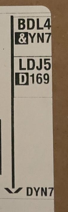
Here’s part of a label on a package that was fulfilled at BDL4, an Amazon Robotics Sortable Fulfillment Center in Windsor, CT. It was then sorted at the LDJ5 Sortation Center in Staten Island, NY before arriving at DYN7, a Delivery Station in Brooklyn, NY. From there it was loaded onto a van headed for the Crown Heights neighborhood of Brooklyn (the name and address are not pictured here, but that information is right next to this facility information on any label).
In theory, if all Amazon customers in the country took pictures of their packages and uploaded them to a central database, we could have a comprehensive picture of Amazon’s entire outbound flow. While that’s not going to happen, maybe if some, even many, people sent me pictures of their package labels, I could begin to trace Amazon’s outbound arcs: what facilities are receiving packages from which other facilities, and which facilities they’re in turn sending packages to.
I was able to get a start on this idea thanks to the Architectural League of New York, for whose publication Urban Omnibus I’m currently working on an article. I asked the staff of the Architectural League to take photos of their Amazon packages for a month (and I asked a few friends in NYC to do the same) and send them to me so that I could better understand how Amazon services New York City. After getting all of the package label data into a spreadsheet, I then asked data scientist Kevin Ouyang to create a map of the package arcs in this small data set representing 137 packages delivered within the five boroughs. Here is what he produced:

This is a dynamic map, meaning that the more rows of package data I add to the underlying spreadsheet, the more arcs will be visualized on the map.
So here goes nothing: if you’re up for it, send me photos of your Amazon package labels! If you want to blur your name/address or just send a picture of the facility information, that’s fine, but at the very least noting a “Neighborhood, City, State” destination helps. For my part, I will keep any personal information included on the label confidential. It also helps to know what was in the package, even in some generic sense: an iPhone charger is going to be coming from a different kind of Fulfillment Center than a mop, for instance.
You can upload the package label photos on this Google Form, or you can just send them to ontheseams.newsletter@gmail.com, ideally with the subject line: “Amazon Package Label,” and again with some indication of the package’s destination/contents if it’s not included in the picture. Alternatively, if you have a solid social media following, share the form or this article and ask people to contribute.
Even in the limited dataset so far, I found some pretty interesting things, like limited use of Sortation Centers around NYC (which I’ll explain more in that forthcoming Urban Omnibus article) and a new third-party Sortation Center in New Jersey, ZEWR. Amazon is constantly opening new facilities and shuttering other ones, and an expanded version of this dataset would help me track those openings and closures, in addition to charting the outbound arcs.
So help me better understand the operations of this modern corporate behemoth by sending me a picture of your recent Amazon package that just came in. It only takes a moment! And if all goes well, the result will be pretty fascinating.
Good luck comrades
Investigating the "Amazon bemouth" does seem like a moral and civic duty. Thanks Benjamin Fong!